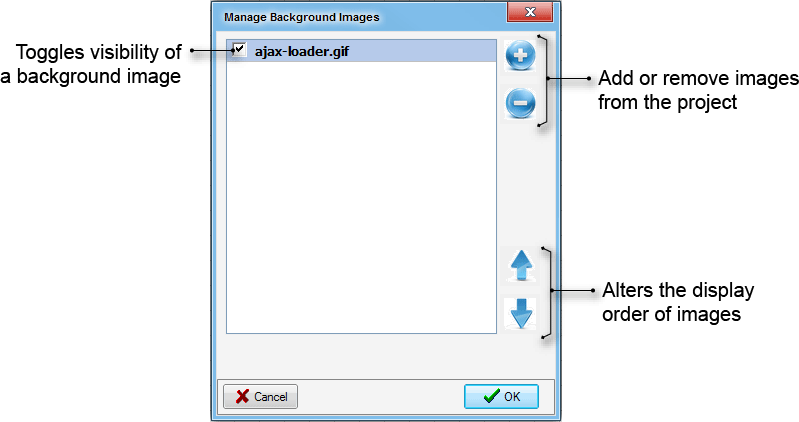
Background Images
Background Image Manager
The Background images manager has been updated in music to provide support for a greater number of background image formats, display of multiple image files simultaneously and support for real world coordinates
MUSIC supports a large range of background image formats, as well as georeferencing (if provided as part of the selected image format). A summary of the image formats supported by music are provided below.
| Image File Format Description | Default File Extension |
|---|---|
| Arc/Info ASCII Grid | *.txt;*.arc;*.asc |
| ADRG/ARC Digitilized Raster Graphics (.gen/.thf) | *.gen |
| Arc/Info Binary Grid (.adf) | *.adf |
| AIRSAR Polarimetric | *.dat |
| Windows Bitmap | *.bmp |
| BSB Nautical Chart Format (.kap) | *.kap |
| VTP Binary Terrain Format (.bt) | *.bt |
| CEOS (Spot for instance) | *.ceos |
| Spot DIMAP (metadata.dim) | *.dim |
| USGS DOQ (.doq) | *.doq |
| Military Elevation Data (.dt0, .dt1, .dt2) | *.dt |
| ERMapper Compressed Wavelets (.ecw) | *.ecw |
| ESRI .hdr Labelled | *.flt |
| Envisat Image Product (.n1) | *.n1 |
| Graphics Interchange Format (.gif) | *.gif |
| GMT Compatible netCDF | *.nc |
| Golden Software Grid | *.grd |
| TIFF / GeoTIFF (.tif) | *.tif |
| GXF - Grid eXchange File | *.gxf |
| Hierarchical Data Format | *.hdf |
| Intergraph Raster | *.cot;*.ctc;*.rgb;*.ctb;*.grd;*.crl;*.tpe;*.lsr;*.rle;*.cit;*.g3;*.g4;*.tg4;*.cmp; |
| Erdas Imagine | *.img |
| drisi Raster | *.rst |
| Japanese DEM | *.mem |
| JPEG | *.jpg |
| JPEG2000 | *.jp2, *.jpk |
| Portable Network Graphics | *.png |
| USGS SDTS DEM | *CATD, *.ddf |
| Raster Matrix Format | *.rsw; *.mtw |
| SRTM HGT Format | *.hgt |
| USGS ASCII DEM | *.dem |
| Multi-resolution Seamless Image Database | *.sid |
Georeferenced images
Many of the above file formats incorporate embedded georeferencing information. In such cases, music will extract this information and display the image in real world coordinates. It should be noted that music does not support re-projection of images. Therefore, if you intend to use multiple images, ensure that all images are georeferenced to a common coordinate system.
If an image does not contain embedded georeferencing information and the you wish to display the image with real world coordinates, it will be necessary to develop a 'world' file. A 'world' (*.wrl) file, is a text file comprising 6 lines of data that determines the location of the image in space. The world file can be created in any text editor. The file must comply with the following structure (information in brackets is for informative purposes only and is not to be included in the world file).
5.000000000000 (size of pixel in x direction in map units, e.g., metres)
0.000000000000 (rotation term for row, typically kept at 0)
0.000000000000 (rotation term for column, typically kept at 0)
-5.000000000000 (size of pixel in y direction in map units, e.g., metres. This should typically be a negative value)
492169.12000000 (x coordinate of upper left corner of image)
5426523.31000000 (y coordinate of upper left corner of image)
In addition, the *wrl file must have the same file name prefix as the image it is being associated with. For example, if you wished to create a world file for a Aerial_Background.jpg file, the world file would need to be called Aerial_Background.wrl.
 Tip Box
The pixel size in the y-direction will typically always be negative.
The coordinates of the cursor in a project are displayed in the bottom left hand corner of MUSIC.
Non-Georeferenced Images
If no georeferencing information is embedded in the image or included in a 'world' file, music will set the bottom left hand corner of the image to co-ordinates of x,y = 0,0 and the image size will
determine the maximum x and y coordinates of the display. For example, an image that is 1000 pixels high and 2000 pixels wide will have its lower left corner at 0,0 and its upper right corner at 2000, 1000.