Buffer Strips
Buffer strips are commonly used as a source control measure, particularly for management of diffuse runoff. Buffer strips are vegetated strips adjacent to drainage lines, rather than constructed vegetated channels, which are known as swales. Buffer strips are effective in the removal of coarse to medium sized suspended solids and bed loads and can be used as a pre-treatment to linear infiltration systems such as bio-retention systems. They also can assist in reduction of peak flows for smaller events and may promote infiltration dependent upon the underlying soil conditions. Buffer strip treatment only applies to runoff from impervious surfaces and can be used to represent catchment conditions where runoff from impervious surfaces needs to flow across grassed areas towards the stormwater drainage system.
 Tip Box
Buffer Strips must be located directly downstream of a source node and cannot be located downstream of a treatment node.
Buffer Strip Properties
The treatment processes in a buffer strip are modelled by a set of simple transfer functions, derived from a review of worldwide literature (Fletcher, unpublished data):
TSSout = 0.27 + (1.8 x 10⁻⁵Hydraulic Load)* x TSSin
TPout = 0.52 + (8 x 10⁻⁶Hydraulic Load)* x TPin
TNout = 0.67 + (9.24 x 10⁻⁶Hydraulic Load)* x TNin
where concentrations are in mg/L, and Hydraulic Load is in m/year.
*For inflow concentrations below defined concentrations (TSS= 13.7mg/L, TP = 0.143 mg/L, TN = 1.680 mg/L), no treatment occurs.
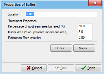
Location
The location name will be displayed under the buffer strip node icon on the main worksheet.
Percentage of Upstream Area Buffered
This refers to the proportion of the Source Node’s impervious area which has buffer strips applied to it. For example, in a Source Node with 20 ha of impervious area, 2 ha (or 10%) may have buffer strips applied.
Buffer Area
This is a measure of the actual size of buffer strips, defined as the percentage of the Source Node impervious area. The default value is 5%. This means that the total area of buffer strip is equivalent to 5% of the Source Node impervious area.
Exfiltration Rate
Exfiltration from the buffer strip into the underlying soil can be modelled by defining the exfiltration rate (mm/hr). Representative exfiltration rates for different soil types are provided in the table over the page. The water that seeps from the buffer strip is lost from the catchment, and cannot re-enter the system downstream. Contaminants in the water that is lost to exfiltration are removed from the buffer strip, along with the exfiltrated water and are also lost from the catchment. Representative exfiltration rates for different soil types are shown in the following table.
| Soil Type | Median particle size (mm) | Saturated Hydraulic Conductivity | |
|---|---|---|---|
| (mm/hr) | (m/s) | ||
| Gravel | 2 | 36000 | 1x10⁻² |
| Coarse sand | 1 | 3600 | 1x10⁻³ |
| Sand | 0.7 | 360 | 1x10⁻⁴ |
| Sandy loam | 0.45 | 180 | 5x10⁻⁵ |
| Sandy clay | 0.01 | 36 | 1x10⁻⁵ |
Tip Box
This simple example may help to explain the specifications for buffer strips. If a Source Node with an impervious area of 100 ha has buffer strips applied to 20 ha, and the buffer strips occupy 5 ha of land:
Percentage of Upstream Impervious Area Buffered = 20%
Buffer Area = 5%

It is possible to record flux data for the buffer, including inflows, outflows, water quality, etc. Data is recorded for each time-step. Refer to Treatment Devices for more information on fluxes.
This data can be exported to a text file, for importing and analysis in other software packages.

The Notes button allows you to record any important details or assumptions for the buffer (for example, you may provide an explanation of how the area was calculated). It is good practice to provide notes of any important assumptions, for future reference by others using the model.