Rainfall runoff models
A rainfall runoff model is used to derive runoff for a particular area from inputs of rainfall and potential evapotranspiration (or areal potential evapotranspiration). All rainfall runoff models in Source are conceptual models that represent catchment hydrological response to rainfall as a series of mathematical relationships. They provide runoff output from each functional unit as total discharge, which is split into quick flow (surface flow) and slow flow (baseflow) proportions. Refer to the Source Scientific Reference Guide for more detail.
Choosing the right model
Choosing and calibrating your rainfall runoff model is essential. The quality of your rainfall runoff calibration can interact with, and affect output from other models. For example, where constituent load is calculated as the product of flow and concentration, any errors in flow estimates will be propagated through to load estimates.
Consider the following when choosing a rainfall runoff model:
- What models do you and other people in your organisation have experience with;
- Have any rainfall runoff models worked well for your catchment in the past;
- What type of catchment are you modelling? (urban, forested, mixed land use);
- What data do you have available? You need to parameterise any models you choose; and
- Do you have any information on previous rainfall runoff model calibrations? If calibrated models already exist, you can re-use the models and parameter sets.
These might also be useful:
- Run a range of different models and determine which ones work best; and
- Consider using different models or parameters, in different sub-catchments or functional units. What works best in one functional unit may not work well in another. For example, different models may be useful where sub-catchments/FUs have different soil types (different soil water holding capacity) or different proportions of urban areas (large differences in impervious runoff).
Refer to the Source Scientific Reference Guide for details on the types of rainfall runoff models.
Working with rainfall runoff models
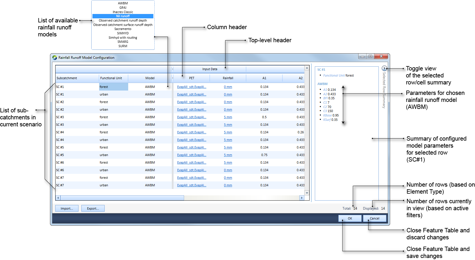
Once a catchments scenario has been created using the Geographic Wizard for catchments, rainfall runoff models can be configured using the Rainfall Runoff Model Configuration dialog (Figure 1). Choose
Filters
Working with filters in the Rainfall Runoff Model configuration dialog is similar to that in the Feature Table. Refer to Working with filters in the Feature Table. The next section details how to work with individual filters.
Sub-catchments
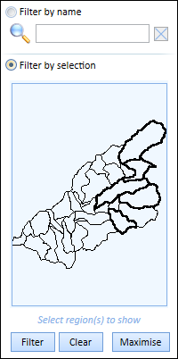
You can choose which sub-catchment to filter on (as shown in Figure 2) either by:
- Name - Select Filter by name, then enter the sub-catchment name in the Name field and click Filter; or
- Choosing the sub-catchments using a map - Select Filter by selection, then click on the sub-catchment by choosing it in the map. The selected sub-catchment will have a black highlighted boundary (as shown in Figure 2). For multiple sub-catchment selection, press Ctrl while clicking one by one on the sub-catchments. Then, click Filter.
Figure 2. Rainfall Runoff Model Configuration, filtering by sub-catchment