Note: This is documentation for version 4.11 of Source. For a different version of Source, select the relevant space by using the Spaces menu in the toolbar above
Water quantity processes - Catchments SRG
Source includes a conceptual rainfall-runoff modelling framework for estimating catchment water yield and streamflow data. This provides the user with the following options:
- Specify nil runoff – no derivation of streamflow data.
- Input a time series of data that is observed or derived externally to Source.
- Generate streamflow data using a rainfall-runoff model.
In addition, flows can be generated using functions.
Two techniques for processing input time series data are available:
- Observed catchment runoff depth - SRG, which includes a model for baseflow separation, and
- Observed catchment surface runoff depth - SRG, which assumes all the data is surface runoff (i.e. no baseflow separation)
The following six rainfall-runoff models are available:
- Australian Water Balance Model (AWBM) - SRG
- GR4J - SRG
- IHACRES-CMD - SRG
- Sacramento Model - SRG (the Sacramento model)
- SIMHYD - SRG and SIMHYD with routing - SRG
- SMARG - SRG
- PERFECT GWlag - SRG
The six rainfall-runoff models can be configured based on: (i) a delineation of the catchment into smaller lumped sub-catchments; or (ii) a lumped catchment scale. Inputs are explicit for each sub-catchment, allowing representation of the heterogeneity in catchments at the sub-catchment scale. Variations in land use, rainfall, evapotranspiration, etc. are lumped at the sub-catchment scale. The models can be calibrated using observed climate and streamflow data in gauged catchments using a combination of objective functions and optimisation methods (the framework includes four optimisation methods and four pre-defined objective functions - more information is available via Calibration analysis - SRG). Models can be used to simulate runoff from ungauged catchments using a suitable regionalisation method; alternatively, it may be possible to estimate parameter values from other studies or from the literature. Model inputs and outputs can be displayed as time series or spatial and temporal plots to assist with quality assurance. The framework also provides a number of descriptive statistics that can be used to assess the quality of model calibration and simulation results. (Abridged from Welsh, et al, 2013.)
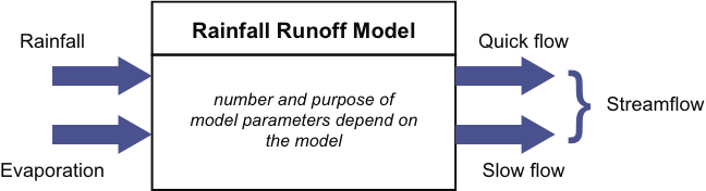
The general approach in these models is to use rainfall and evaporation data as inputs. Stream flow is produced as a model output, often as the sum of quick flow and slow flow components, as illustrated in Figure 1 (Note that quick flow may includs lateral subsurface throughflow - also known as interflow - as well as surface runoff). If evaporation data is not available, temperature may be used as an input in some models (e.g. IHACRES Classic). The complexity of the models varies considerably from four parameter models (e.g. GR4J) to models with a large number of conceptual stores and parameters (e.g. the Sacramento model).
Figure 1. Rainfall runoff model
Choosing the right model
Choosing which of the above models is the most appropriate to use for a given application may not necessarily be straightforward. Consider the following when choosing a rainfall runoff model:
- What models do you and other people in your organisation have experience with;
- Have any rainfall runoff models worked well for your catchment in the past;
- What type of catchment are you modelling? (urban, forested, mixed land use);
- What data do you have available? You need to parameterise any models you choose; and
- Do you have any information on previous rainfall runoff model calibrations? If calibrated models already exist, you can re-use the models and parameter sets.
These approaches might also be useful:
- Run a range of different models and determine which ones work best; and
- Consider using different models or parameters, in different sub-catchments or functional units. What works best in one functional unit may not work well in another. For example, different models may be useful where sub-catchments/FUs have different soil types (different soil water holding capacity) or different proportions of urban areas (large differences in impervious runoff).
- Use an ensemble of models
More information on model choice, and rainfall-runoff modelling as a whole, is available from a number of sources including eWater's Guidelines for water management modelling and the supporting Guidelines for Rainfall-Runoff Modelling (accessible via the link for Guidelines for water management modelling).
Reference
Welsh, W.D., Vaze, J., Dutta, D., Rassam, D., Rahman, J.M., Jolly, I.D., Wallbrink, P., Podger, GM., Bethune, M., Hardy, M.J., Teng, J., Lerat, J. (2013) An integrated modelling framework for regulated river systems. Environmental Modelling & Software, 39: 81-102.