Note: This is documentation for version 4.11 of Source. For a different version of Source, select the relevant space by using the Spaces menu in the toolbar above
Sacramento Model - SRG
Theory
Introduction
The Sacramento Model is a continuous rainfall-runoff model used to generate daily stream flow from daily rainfall and potential evapotranspiration data. It uses soil moisture accounting to simulate the water balance within the catchment (i.e. functional unit). The conceptual layout of the model is shown in Figure 1. At each model time step the sequence of calculations is:
- Soil moisture depletion by evapotranspiration and soil moisture redistribution.
- Soil moisture replenishment by rainfall and percolation, and streamflow generation.
The internal Sacramento Model calculations represent water quantities using units of depth (in millimetres). The model outputs are converted to volumes by multiplying by the catchment area.
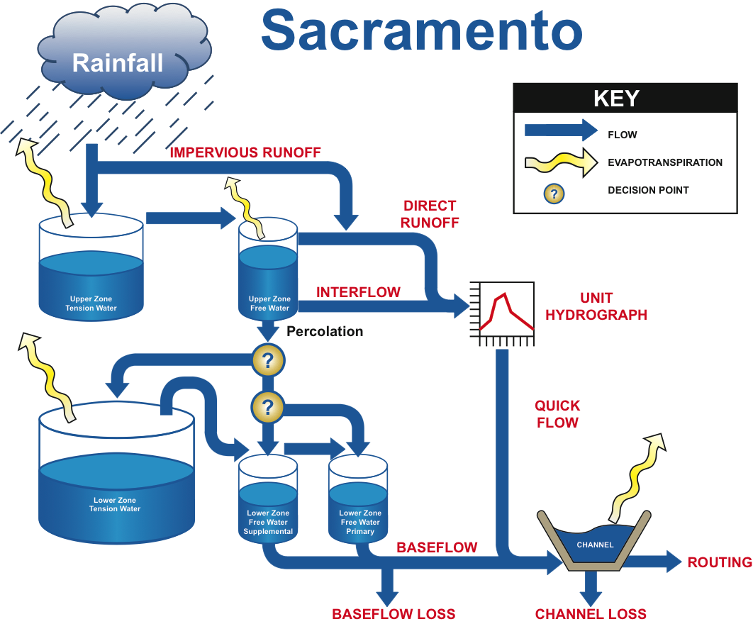
Figure 1. Sacramento Model
 Selecting stream flow data to use in a river-basin-scale simulation study needs information about the reliability of the data. It is best to use data which are most representative of the stream flow from the catchment. Observed data would normally be selected, except where the data are of poor quality or of unknown reliability. |
There are five stores in the Sacramento Model:
- Upper zone tension water (UZTW);
- Upper zone free water (UZFW);
- Lower zone tension water (LZTW);
- Lower zone primary free water (LZFWP); and
- Lower zone supplementary free water (LZFWS).
The tension water stores represent the volume of water that is held in the soil matrix by surface tension. Water can only be removed from the tension water stores by evapotranspiration. In the case of the free water stores, water can move through the soil vertically and laterally to other stores, and be discharged as interflow (upper zone) or baseflow (lower zone).
The Sacramento Model divides the catchment into impervious and pervious areas. The impervious area is the portion of the catchment that is covered by lakes, rivers, pavement and other impervious surfaces that are directly connected to the stream network. The impervious area produces runoff from any rainfall while the pervious area only produces runoff when rainfall is sufficiently heavy. The Sacramento model also allows the user to specify a variable impervious area, which is a portion of the catchment that can become impervious when the catchment is quite saturated.
Streamflow generated by the Sacramento Model is made up of four main forms:
- impervious runoff from permanent impervious areas and direct runoff from variable impervious areas,
- surface runoff, which occurs when Upper Zone Free Water storage is full and the precipitation intensity exceeds the rate of percolation and interflow
- interflow resulting from the lateral drainage of the Upper Zone Free Water storage
- baseflow, which is composed of primary and supplemental baseflow
Impervious runoff, direct runoff and surface runoff have no time delay in the Sacramento model, occurring in the same time interval as the rain that generated the runoff component. Interflow generally has a time delay in terms of days, supplemental baseflow a delay of weeks or months and primary baseflow a delay of months or years.The generation of surface runoff, interflow and baseflow depends on the amount of water in each soil moisture store relative to that store’s capacity, and the rate at which water moves into and out of the stores.
Further details are in the following sections.
Soil moisture depletion and redistribution
Depletion
The upper limit of evapotranspiration is the potential evapotranspiration demand, ED, specified by the modeller. Soil moisture depletion by evapotranspiration takes place as follows.
Evapotranspiration occurs firstly from UZTW:
| Equation 1 | 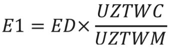 |
|---|
Where:
UZTWC = current contents of upper zone tension water store (state variable)
UZTWM = capacity of upper zone tension water store (parameter)
Then, if there is potential demand unsatisfied, evapotranspiration occurs from UZFW:
| Equation 2 | 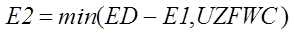 |
|---|
Where:
UZFWC = current contents of upper zone free water store (state variable)
If there is still potential demand unsatisfied then the remainder is satisfied as much as possible from LZTW:
| Equation 3 | 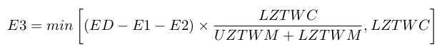 |
|---|
Where:
LZTWC = current contents of lower zone tension water store (state variable)
LZTWM = capacity of lower zone tension water store (parameter)
There is also an additional store, with current contents of ADIMC, related to the parameter ADIMP, the additional area that behaves as impervious when UZTW is full. This store can be depleted by evapotranspiration as well:
| Equation 4 | 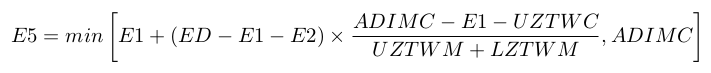 |
|---|
Evaporation can also occur directly from the stream as governed by the modeller specified parameter, SARVA:
| Equation 5 | 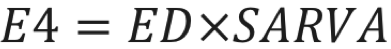 |
|---|
Redistribution
Soil moisture is redistributed from the free water stores to the tension water stores as follows:
- If the ratio of UZFWC to UZFWM is greater than the ratio of UZTWC to UZTWM, water is transferred from UZFW to UZTW until the ratios are equal (but the reverse does not occur).
- If the ratio of the combined current contents of the three lower zone stores (less the modeller specified RSERV component) to the combined capacities of these stores (also less the modeller specified RSERV component) is greater than the ratio of LZTWC to LZTWM, alone, then the ratios are equalised by firstly transferring water from LZFWS to LZTW, and secondly, if there is insufficient water in LZFWS to achieve equalisation, by transferring water from LZFWP to LZTW.
Soil moisture replenishment and percolation, and streamflow generation
Overview
The sequence of calculations in this phase, for each model time step, is as follows:
- Replenish the upper zone tension water store.
- Compute supplemental and primary baseflow from the two lower zone free water stores.
- Compute total percolation from the UZFW store to the three lower zone stores.
- Compute interflow (from the UZFW store).
- Distribute percolation water between the lower zone free water stores, collectively, and the LZTW store.
- Distribute percolation water available to lower zone free water stores between primary and supplemental stores.
- Replenish upper zone free water store (UZFW) with any overflow from upper zone tension water store and, if UZFW overflows, compute surface runoff.
- Calculate instantaneous runoff, being the sum of surface runoff, impervious runoff ROIMP, and any contribution due to ADIMP.
Impervious areas
All rain falling on the permanently impervious area (defined by PCTIM) runs off; that is, it is not subject to depletion by evaporation. Hence:
| Equation 6 |  |
|---|
The runoff contribution due to ADIMP is calculated as follows:
- The store ADIMC is replenished by the same amount of rainfall as used to replenish the UZTW store (this occurs after the UZTW store is replenished, see below).
- If the UZTW store is full then additional runoff is calculated:
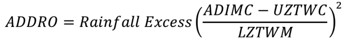
- If the Rainfall Excess exceeds the available capacity of the LZTW store, the rainfall remaining after the LZTW store is filled is used to generate an additional contribution to ADDRO.

- The contents of the store ADIMC are updated:

- Lastly, ROIMP is updated:
| Equation 7 |  |
|---|
Pervious areas
For the pervious areas, the UZTW store receives the rain first: depending on the available capacity, either all the rain goes into this store, or as much as is needed to fill the store goes in and the remainder is Rainfall Excess. Once the UZTW store is filled, water goes to the UZFW store. The UZFW store then supplies water to the three lower zone stores simultaneously, with a modeller determined split between the free water and tension water stores. When both the LZFWP and LZFWS are filled, all water goes to the LZTW store.
Percolation
Percolation to the lower zone soil moisture stores is a key process of the Sacramento Model. The driving force for percolation is the relative wetness of the UZFW store, as moderated by the relative wetness of the lower zone stores.
Percolation increases when either the storage in the UZFW store increases or the storage in the lower zone stores decrease. This is equivalent to supply increasing and demand increasing respectively. Conversely, percolation decreases when the lower stores start becoming full.
The lower limit of percolation, Pbase, occurs when the lower zones are saturated, and is determined by the rate at which the lower zones drain (Equation 8). The maximum rate of percolation occurs when the lower zones are dry, and Pbase is factored up using the ZPERC parameter (Equation 9).
| Equation 8 |  |
|---|
| Equation 9 | 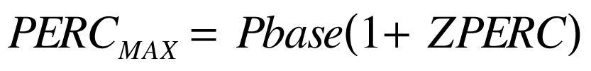 |
|---|
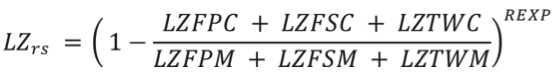
The actual percolation is moderated by the relative saturation of the lower and upper zones, which is the ratio of current storage contents to the maximum storage in these stores (Equation 10).
Equation 10 |  |
|---|
Where:
- LZrs moderates the maximum percolation demand based on the assumption that the change in the lower zone percolation demand is exponentially related to the ratio (lower zone deficiency/lower zone capacity):
- UZrs modifies the percolation demand by a function of the available water supply in the upper zone:
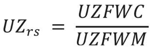
The final percolation is then the minimum of the result from Equation 10, the current contents of the UZTW store (UZFWC), and the lower zone water deficiency which is ((LZTWM+ LZFSM+LZFPM)-(LZTWC+LZFSC+LZFPC)).
Equation 8 and Equation 10 are written assuming the parameter SIDE has the value of zero. If SIDE is non-zero, LZFSM and LZFPM are increased by the ratio specified by SIDE (i.e. multiplied by 1+SIDE).
Normally, the lower zone tension store (LZTW) would fill before water goes to the lower zone free water stores. However, variations in soil types cause deviations from average conditions and therefore in the Sacramento Model a fraction of the percolation (PFREE) is made available for lower zone free water stores before LZTW fills. The potential percolation to the LZTW store is given by Equation 11.
| Equation 11 |  |
|---|
At each model time step the actual percolation to the LZTW store is then the minimum of the result from Equation 11 and the unfilled capacity of the LZTW store. Any percolation water left over after this step is available for the two lower zone free water stores (PERCFW). This is firstly allocated to the LZFWS store:
| Equation 12 |  |
|---|
Where:
| Equation 13 |  |
|---|
| Equation 14 |  |
|---|
| Equation 15 | 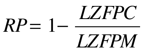 |
|---|
The contents of the LZFW store are updated for the result from Equation 12:
| Equation 16 |  |
|---|
The contents of the LZFWP are then updated:
| Equation 17 |  |
|---|
If, from Equation 17, LZFPM is exceeded the surplus is transferred back to the LZFWS store and:

In theory, this means that LZFSC could exceed LZFSM but the checks elsewhere (e.g. in Equation 12) mean this should never occur in practice.
Surface runoff
Surface runoff is runoff occurring when UZFW is full. While it is a depth, it is a depth over the pervious area of the catchment (functional unit) and it must be adjusted for impervious areas so it represents a depth over the total catchment. Hence, when UZTW and LZTW are both full:
| Equation 18 |  |
|---|
Before routing via the unit hydrograph methodology (see the Time Delay Tools section below), instantaneous runoff is calculated as the sum of runoff from the impervious area, ROIMP, additional impervious runoff due to ADIMP when UZTW and LZTW are both full, interflow and surface runoff.
Interflow
Interflow is generated from the UZFW store as the product of the volume of water in the store, and the modeller specified drainage rate parameter, UZK.
| Equation 19 | 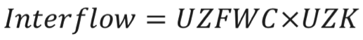 |
|---|
The result from Equation 19 is adjusted for impervious areas in the same way as surface runoff.
Baseflow
Base flow is calculated in a similar manner to interflow, using the water in the lower zone free water stores with their corresponding (modeler specified) drainage rate parameters, LZPK and LZSK. The base flow is then reduced by channel loss parameters, SIDE and SSOUT.
| Equation 20 |  |
|---|
| Equation 21 |  |
|---|
| Equation 22 | 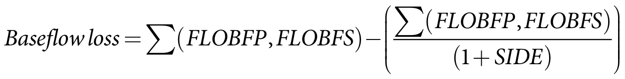 |
|---|
| Equation 23 | 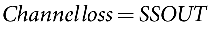 |
|---|
The resultant total baseflow (Baseflow loss in Equation 22) is adjusted for impervious areas in the same way as surface runoff.
Time delay tools
The instantaneous runoff and interflow can be delayed to better represent stream flow hydrographs. The Sacramento Model uses a unit hydrograph for this purpose. Each ordinate (UH1...5) represents the proportion of flow which will reach the channel outlet in successive time periods. The Sacramento Model also uses a layered routing process.
Other factors
Other inputs that can also be altered in the calibration process include the parameter RSERV (Fraction of lower zone free water unavailable for transpiration).
Input data
The model requires daily rainfall and potential evapotranspiration data (Note: the original Sacramento Model used pan evaporation but the Source version does not). The rainfall and evapotranspiration data sets need to be continuous (no gaps) and be for the same time period.
Daily rainfall data may be obtained from rain gauges or rainfall surfaces but will need to be converted to a time series record that is spatially representative of the whole catchment. Note that the time that rainfall data are collected may be important. Very often rainfall data are collected in the morning, the usual time is 9 am, and may be more representative of the previous day’s rainfall. Daily evaporation is an estimate of the spatially averaged evaporation rate of the catchment being modelled. This estimate is subject to the types of land uses that are in the catchment. This may be estimated by applying a crop/land use factor to daily pan or potential evapotranspiration surface data. Daily flow data in ML/d, m3/s or mm/d may be required to calibrate the model. |
Parameters or settings
The Sacramento model uses a total of sixteen parameters to simulate the water balance. Of these:
- five define the size of soil moisture stores (UZTWM, UZFWM, LZTWM, LZFSM, LZFPM);
- three calculate the rate of lateral outflows (LZPK, LZSK, UZK);
- three calculate the percolation of water from the upper to the lower soil moisture stores (PFREE, REXP, ZPERC);
- two calculate impervious runoff (PCTIM, ADIMP);
- three calculate losses in the system (SIDE, SSOUT, SARVA);
- five allow time delays to be applied to instantaneous runoff (UH1…UH5); and
- the final parameter, RSERV, has very low sensitivity and optimization of this term is generally not warranted (Burnash et al, 1973).
The model parameters are summarised in Table 1. In the table, typical minimum and maximum values represent the default parameter ranges used by the Source Calibration Wizard for rainfall-runoff calibration. They are largely derived from Anderson (2002, Chapter 7), who proposed the ranges based on experience with the Sacramento model over a wide range of physiographic conditions. In some applications, the parameter values could fall outside of these ranges.
Table 1. Model Parameters
Parameter | Description | Units | Default | Typical Min | Typical Max |
LZPK | The ratio of water in LZFPM, which drains as base flow each day. | fraction | 0.01 | 0.001 | 0.015 |
LZSK | The ratio of water in LZFSM which drains as base flow each day. | fraction | 0.05 | 0.03 | 0.2 |
UZK | The fraction of water in UZFWM, which drains as interflow each day. | fraction | 0.3 | 0.2 | 0.5 |
UZTWM | Upper Zone Tension Water Maximum. The maximum volume of water held by the upper zone between field capacity and the wilting point which can be lost by direct evaporation and evapotranspiration from soil surface. This storage is filled before any water in the upper zone is transferred to other storages. | mm | 50 | 25 | 125 |
UZFWM | Upper Zone Free Water Maximum, this storage is the source of water for interflow and the driving force for transferring water to deeper depths. | mm | 40 | 10 | 75 |
LZTWM | Lower Zone Tension Water Maximum, the maximum capacity of lower zone tension water. Water from this store can only be removed through evapotranspiration. | mm | 130 | 75 | 300 |
LZFSM | Lower Zone Free Water Supplemental Maximum, the maximum volume from which supplemental base flow can be drawn. | mm | 25 | 15 | 300 |
LZFPM | Lower Zone Free Water Primary Maximum, the maximum capacity from which primary base flow can be drawn. | mm | 60 | 40 | 600 |
PFREE | The minimum proportion of percolation from the upper zone to the lower zone directly available for recharging the lower zone free water stores. | percent/100 | 0.06 | 0.0 | 0.5 |
REXP | An exponent determining the rate of change of the percolation rate with changing lower zone water storage. | none | 1.0 | 0.0 | 3.0 |
ZPERC | The proportional increase in Pbase that defines the maximum percolation rate. | none | 40 | 0.0 | 80 |
SIDE | The ratio of non-channel baseflow (deep recharge) to channel (visible) baseflow. | ratio | 0.0 | 0.0 | 0.8 |
SSOUT | The volume of the flow which can be conveyed by porous material in the bed of stream. | mm | 0.0 | 0.0 | 0.1 |
PCTIM | The permanently impervious fraction of the basin contiguous with stream channels, which contributes to direct runoff. | percent/100 | 0.01 | 0.0 | 0.05 |
ADIMP | The additional fraction of the catchment which develops impervious characteristics under soil saturation conditions. | percent/100 | 0.0 | 0.0 | 0.2 |
SARVA | A decimal fraction representing that portion of the basin normally covered by streams, lakes and vegetation that can deplete stream flow by evapotranspiration. | percent/100 | 0.0 | 0.0 | 0.1 |
RSERV | Fraction of lower zone free water unavailable for transpiration | percent/100 | 0.3 | 0.0 | 0.4 |
UH1 | The first component of the unit hydrograph, i.e. the proportion of instantaneous runoff not lagged | percent/100 | 1.0 | 0 | 1 |
UH2 | The second component of the unit hydrograph, i.e. the proportion of instantaneous runoff runoff lagged by one time-step | percent/100 | 0.0 | 0 | 1 |
UH3 | The third component of the unit hydrograph, i.e. the proportion of instantaneous runoff runoff lagged by two time-steps | percent/100 | 0.0 | 0 | 1 |
UH4 | The fourth component of the unit hydrograph, i.e. the proportion of instantaneous runoff runoff lagged by three time-steps | percent/100 | 0.0 | 0 | 1 |
UH5 | The fifth component of the unit hydrograph, i.e. the proportion of instantaneous runoff runoff lagged by four time-steps | percent/100 | 0.0 | 0 | 1 |
In Source, up to five unit hydrograph terms (UH1...UH5) can be set to lag the runoff over time. When using RRL v1.0.5 the unit hydrograph term is fixed at 1 for the first time increment, and 0 for the subsequent time increments, and therefore no unit hydrograph routing is applied in RRL. Equivalent behaviour would be achieved with the Sacramento Model in Source by setting UH1 = 1 and UH2 through UH5 to 0. |
The sum of the unit hydrograph terms should always be 1, however if it is not 1, Source will internally normalise the unit hydrograph terms. Calibration Wizard automatic calibration may result in the sum exceeding 1 in some cases. |
The Sacramento Model in Source is configured with a set of default values for each model parameter. There are also upper and lower bounds for each parameter.
As with any modelling, the accuracy and reliability of the results from the Sacramento Model are determined by how representative the model is of the catchment (particularly as the Sacramento Model is lumped) and also by the quality of the rainfall, evaporation and stream flow data used. The accuracy and reliability of the model can be assessed using the results of comparisons with observed data. As a rule, the calibrated parameter values of a specific catchment should not be transposed to other catchments, unless the reliability of this transposition can be assessed. The parameter set is unique to the climate, topography, size, geology, soil and vegetation type of the catchment on which it was calibrated. There is no proven methodology to adjust these parameters to other catchments, including subcatchments, of the calibrated catchment. |
Output data
The model outputs daily surface and base flow. This may be saved in ML/d, m3/s or mm/d.
Reference list
Anderson, E. (2002) Calibration of conceptual hydrological models for use in river forecasting. NOAA Technical Report, NWS 45, Hydrology Laboratory, August 2002.
Burnash, R.J.C, Ferral, R.L. & McGuire, R.A. (1973) A generalized streamflow simulation system: conceptual modeling for digital computers, Technical Report, Joint Federal and State River Forecast Center, US National Weather Service and California Department of Water Resources, Sacramento, CA.
Bibliography
Rainfall Runoff Library v1.0.5, June 25, 2004 (http://www.toolkit.net.au/Tools/RRL).
NOAA Document explaining the conceptualisation of the Sacramento Model.
NOAA version of the soil moisture accounting model (in Fortran).