Note: This is documentation for version 5.0 of Source. For a different version of Source, select the relevant space by using the Spaces menu in the toolbar above
Urban Water User Parameteriser
The Urban Water User Parameteriser allows the automatic population of dwelling counts and occupancy distributions for Urban Water User nodes. The Parameteriser is designed to be used with ABS Census population and housing data for SA2 areas, but it can be applied to other dwellings and occupancy datasets, provided that they are formatted appropriately.
The Urban Water User Parameteriser has two modes of operation:
- User Generated Distributions: the user constructs a CSV file listing the urban water user node names and the corresponding dwelling counts broken down by dwelling type and occupancy. The CSV file is loaded via the Urban Water User Parameteriser, which automatically populates the dwelling counts and occupancy tables of the urban water user nodes.
- Automatically Calculated Distributions: using an external GIS application (e.g. ArcGIS), the user intersects the urban water user distribution zones and ABS SA2 shapefiles, and calculates the area of the intersected polygons. The user also exports the ABS SA2 dwelling types and occupancies data in a data table (CSV file). The intersected distribution zone – ABS shapefile and the data table are imported via the Spatial Data Import Tool, which automatically:
- calculates the dwelling & occupancy distributions for each distribution zone
- populates the urban water user nodes with this data
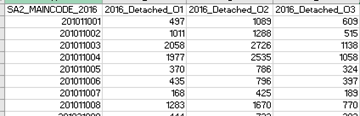
To enable automatic population of the dwellings & occupancy data, a consistent naming convention is required for the data table, which requires some minor pre-processing of the ABS Census data. The naming convention for the data table columns is: [DwellingType]_O[NumberOccupants]. An example data table derived from the 2016 Census data is illustrated below:
Figure 1. Example ABS SA2 area data table.
Restrictions
The Urban Water User Parameteriser is a feature of the Urban Developer Plugin that is available for eWater Source Schematic (River Manager) and Catchments Scenarios.
Dependencies
None
Contents
Outputs
The Urban Water User Parameteriser sets the dwelling counts and occupancy distributions for all Urban Water User nodes (provided that they are appropriately configured).
User Interface
The Urban Water User Parameteriser is accessed via the Source Toolbar menu item Edit » Urban Demand Configuration.
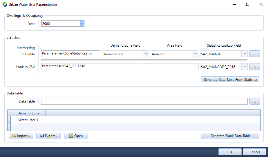
The Urban Water User Parameteriser user interface is illustrated in Figure 1, and the main functionality listed in Table 1.
Figure 1. Urban Water User Parameteriser user interface.
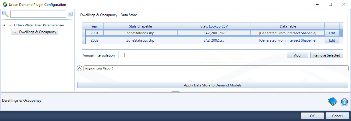
Table 1. Urban Water User Parameteriser options.
| Option | Description |
|---|---|
| Add | Add a new row (data table) to the data store |
| Edit | Edit the selected row (data table) in the data store. This opens the Parameteriser, described below. |
| Remove Selected | Delete the selected row (data table) from the data store |
| Annual Interpolation | Interpolate the loaded data tables, containing dwelling counts & occupancy data, on an annual basis |
| Apply Data Store to Demand Models | Apply the data store to all matching Urban Water User nodes in the scenario |
Parameteriser
Selecting Edit for opens the Parameteriser editor, illustrated in Figure 2.
Figure 2. Parameteriser editor user interface.